Aerial Photography & Drone Shoots in Nepal
AERIAL & DRONE PHOTOGRAPHY NEPAL
Commissioned Aerial Photography From Nepal, The Himalayas And Beyond
PROFESSIONAL AERIAL IMAGING · COMMERCIAL · EDITORIAL · ENVIRONMENTAL · ARCHITECTURE · DESTINATION · FINE ART
The photograph comes first.
The aircraft, camera and flight operation are built around it.
THIS IS COMMISSIONED PHOTOGRAPHY
We do not offer recreational drone flights or casual aerial snapshots.
Every assignment begins with a photographic objective, a location, a plan and the permissions required to carry it out properly.
If you need an aerial photograph that has a purpose, we can build the operation around it.
LEGAL. PLANNED. PROFESSIONAL.
EVERY FLIGHT. EVERY LOCATION. EVERY COMMISSION.
Aerial work in Nepal can involve aviation, security, location and other permissions depending on the assignment.
We handle the production process accordingly.
No shortcuts. No informal flights. No “let's just put the drone up.”
We only undertake aerial work that can be properly planned, permitted and operated.
WE DO NOT START WITH THE DRONE
WE START WITH THE PHOTOGRAPH.
Perhaps you need a glacier from a particular direction.
A building within its urban context.
A resort surrounded by its landscape.
A river system seen from above.
A Himalayan settlement at a particular season.
Or an image that simply does not exist yet.
Tell us what you need to see.
We work backwards from the photograph.
ONE COUNTRY. EXTRAORDINARY RANGE.
Nepal changes dramatically from south to north.
Terai and jungle.
Rivers and wetlands.
Historic cities.
Temples and monuments.
Terraced agriculture.
Forests and protected areas.
High mountain valleys.
Glaciers and snowfields.
The Himalayas.
From the plains to the highest mountains, the aerial possibilities are enormous.
FROM THE CITY TO THE HIMALAYAS
AERIAL PHOTOGRAPHY DOES NOT HAVE TO MEAN MOUNTAINS.
Architecture.
High-rise buildings.
Hotels and resorts.
Heritage sites.
Urban development.
Infrastructure.
Roads and bridges.
Hydropower.
Agriculture.
Forests.
National parks.
Rivers.
Lakes.
Glaciers.
Mountain settlements.
The same professional approach applies whether we are working above Kathmandu or deep in the Himalayas.
FOR ARCHITECTURE & THE BUILT ENVIRONMENT
An aerial photograph can show what a ground-level photograph cannot.
The building.
Its surroundings.
Its relationship with the city.
Its landscape.
Its access.
Its scale.
Its geometry.
We work with architects, developers, hotels, resorts, designers and other built-environment clients who need the whole picture.
FOR TOURISM & HOSPITALITY
SHOW THE PLACE. NOT JUST THE ROOM.
Aerial imagery can reveal the journey, the setting and the experience around a destination.
Hotels. Resorts. Lodges. Retreats. Adventure properties. Destination campaigns. Tourism organisations.
From a luxury property in Kathmandu to a mountain lodge surrounded by the Himalayas, the photograph can sell context before the guest ever arrives.
FOR ENVIRONMENT & CONSERVATION
FROM BEAUTIFUL IMAGE TO VISUAL EVIDENCE.
Aerial photography can document landscapes that are difficult to understand from the ground.
Glaciers.
Rivers.
Watersheds.
Forests.
Wetlands.
Agricultural patterns.
Landslides.
Floods.
Changing settlements.
Environmental transformation.
This makes aerial photography valuable to conservation organisations, researchers, universities, environmental programmes, documentary projects and climate communication.
FOR DEVELOPMENT & INFRASTRUCTURE
SEEING THE SCALE OF A PROJECT.
Roads. Bridges. Hydropower. Transmission lines. Airports. Construction. Water systems. Renewable energy. Urban expansion. Rural development.
Aerial photography can document progress, geography, relationships and scale in ways ground photography cannot.
For development organisations, engineering teams, infrastructure companies, researchers and communications teams, the aerial view can become an important part of the visual record.
EMERGENCY, DISASTER & RAPID VISUAL DOCUMENTATION
WHEN THE GROUND IS DIFFICULT TO SEE.
After an earthquake, flood, landslide, fire or other major event, an aerial view can quickly reveal the scale of damage, affected infrastructure, access routes, settlements and changes to the landscape.
Gautam Dhimal's experience includes Dealing with Disasters, a documentary he produced and photographed in the aftermath of the 2015 Nepal earthquake.
Today, Location Nepal and its wider network can bring together photographers, filmmakers, journalists, researchers and other visual storytellers when a situation requires rapid, responsible documentation.
When access is difficult, the right visual team can become part of the record.
FOR HERITAGE & CULTURE
A monument is never only a monument.
It sits within a street.
A neighbourhood.
A historic city.
A landscape.
A living community.
Aerial photography can reveal those relationships while creating powerful imagery for heritage conservation, architecture, research, publishing and cultural institutions.
FOR BRANDS & CAMPAIGNS
SOMETIMES THE CAMPAIGN NEEDS TO SEE THE WORLD DIFFERENTLY.
Outdoor brands. Automotive. Fashion. Luxury. Travel. Adventure. Hospitality. Technology. Sport. Corporate campaigns.
Aerial photography can provide the hero image, the establishing frame, the campaign landscape or the visual element that makes the entire concept larger.
FOR DOCUMENTARY & HUMAN STORIES
Aerial photography can place a human story within its geography.
A settlement beside a river.
A community surrounded by mountains.
A road connecting remote villages.
A landscape changing around the people who live in it.
We can integrate commissioned aerial stills into wider documentary and visual storytelling projects when the aerial perspective adds something meaningful.
FOR RESEARCH & KNOWLEDGE
SOME PHOTOGRAPHS ARE MADE TO BE LOOKED AT. OTHERS ARE MADE TO BE STUDIED.
Aerial imagery can support research, environmental documentation, geographic storytelling, academic projects, heritage studies, conservation work and long-term visual archives.
Where the assignment requires more than a beautiful photograph, we build the photographic operation around the intended use.
THE RIGHT AIRCRAFT DEPENDS ON THE PHOTOGRAPH
WE HAVE MORE THAN ONE WAY TO GET THERE.
For lighter and more agile assignments, we can work with professional compact aerial platforms such as the DJI Mavic 4 Pro Cine, with additional batteries and the supporting equipment required for a proper field operation.
For more demanding photographic requirements, the DJI Inspire 3 can provide a larger professional platform with multiple lens options.
And when the assignment requires a substantially larger camera payload or a different aerial platform, other systems can be sourced according to the brief.
The equipment is selected for the image, not the other way around.
SOMETIMES THE DRONE IS NOT THE ANSWER
Aerial photography can also mean helicopter.
Especially when the photograph requires:
Greater altitude. A wider geographical relationship. A particular angle of approach. Longer distance observation. Open door photography. A larger camera system. Or access that a drone cannot provide.
Our aerial work can therefore extend beyond UAVs when the photographic objective calls for it.
ONE PHOTOGRAPH OR AN ENTIRE COLLECTION
A commission may be one very specific image. Or it may become a visual collection.
A city. A mountain region. A river system. A chain of hotels. A national park. An architectural portfolio. A climate archive. A destination campaign. A book. An exhibition.
We can plan the work accordingly.
SINGLE CREW OR MULTI-DEPARTMENT PRODUCTION
Some assignments need a photographer and pilot.
Others require much more.
Production management. Location scouting. Ground crew. Safety support. Local specialists. Researchers. Environmental experts. Film crews. Multiple photographers. Multiple aircraft.
Location Nepal can build the appropriate operation around the assignment.
The size of the crew follows the objective.
THE LOCATION MATTERS MORE THAN THE MAP
WHERE SHOULD THE PHOTOGRAPH ACTUALLY BE MADE?
The strongest aerial image is rarely about simply arriving at a GPS point.
We consider season. Light. Weather. Landscape. Access. Altitude. Aircraft capability. Subject movement. Background. Perspective. Permissions.
And what the photograph is ultimately meant to communicate.
A location is selected for the photograph, not simply because it is famous.
NEPAL IS NOT ONE AERIAL LANDSCAPE
EAST TO WEST. SOUTH TO NORTH.
Everest and Khumbu. Makalu and the eastern Himalayas. Annapurna. Manang. Mustang. Langtang. Dolpo. Saipal and Api. Western Nepal. The Terai. Kathmandu Valley. And countless landscapes between them.
Different geography creates different photographs. Different seasons create different Nepal.
HIGH ALTITUDE CHANGES EVERYTHING
At altitude, an aerial assignment becomes a different kind of operation.
Weather can change quickly. Access becomes difficult. Equipment has to be considered carefully. Flight planning becomes more demanding. People and aircraft have different limitations.
That is why high altitude aerial photography requires more than a drone and a good camera.
Experience becomes part of the equipment.
EVERY COMMISSION HAS A SAFETY PLAN
PROFESSIONAL AERIAL PHOTOGRAPHY IS AN OPERATION.
We consider the aircraft, crew, location, weather, airspace, people on the ground, equipment, communications, emergency considerations and operational limitations before the flight.
Where an assignment requires additional specialists or safety resources, we build them into the operation.
The photograph matters. Nobody's safety matters less.
PERMISSIONS ARE PART OF THE PHOTOGRAPH
Every commissioned aerial operation is planned with the applicable permissions and clearances required for the specific location and assignment.
That can involve aviation authorities, security authorities, local authorities, property owners or other concerned bodies depending on the work.
We do not treat permissions as an afterthought.
They are part of the production.
THE PROFESSIONAL DIFFERENCE
There is a big difference between owning a drone and producing an aerial photograph professionally.
A recreational user asks:
“Where can I fly?”
A professional commission asks:
“What does the photograph require?”
That changes everything.
The planning. The permissions. The aircraft. The crew. The timing. The location. The safety.
And ultimately, the photograph.
GAUTAM DHIMAL
PHOTOGRAPHER. PRODUCER. AERIAL VISUAL STORYTELLER.
Gautam Dhimal has been working with aerial photography and demanding aerial visual assignments in Nepal since 2005.
His experience spans photography, production, documentary work, fashion, landscapes, high altitude environments, helicopters, drones and international productions.
That experience brings a different perspective to commissioned aerial work.
The objective is never simply to get the camera into the air. It is to make the photograph worth the flight.
THE VANISHING HIMALAYAS
AERIAL PHOTOGRAPHY AS A LONGER CONVERSATION.
The Vanishing Himalayas is part of Gautam Dhimal's continuing work around the Himalayan environment, beginning with a focused visual conversation around Everest and the Khumbu region.
The work is developing through photography, research, publication, exhibitions, education and wider collaborations.
It is one example of what happens when an aerial photograph becomes part of something larger than a single assignment.
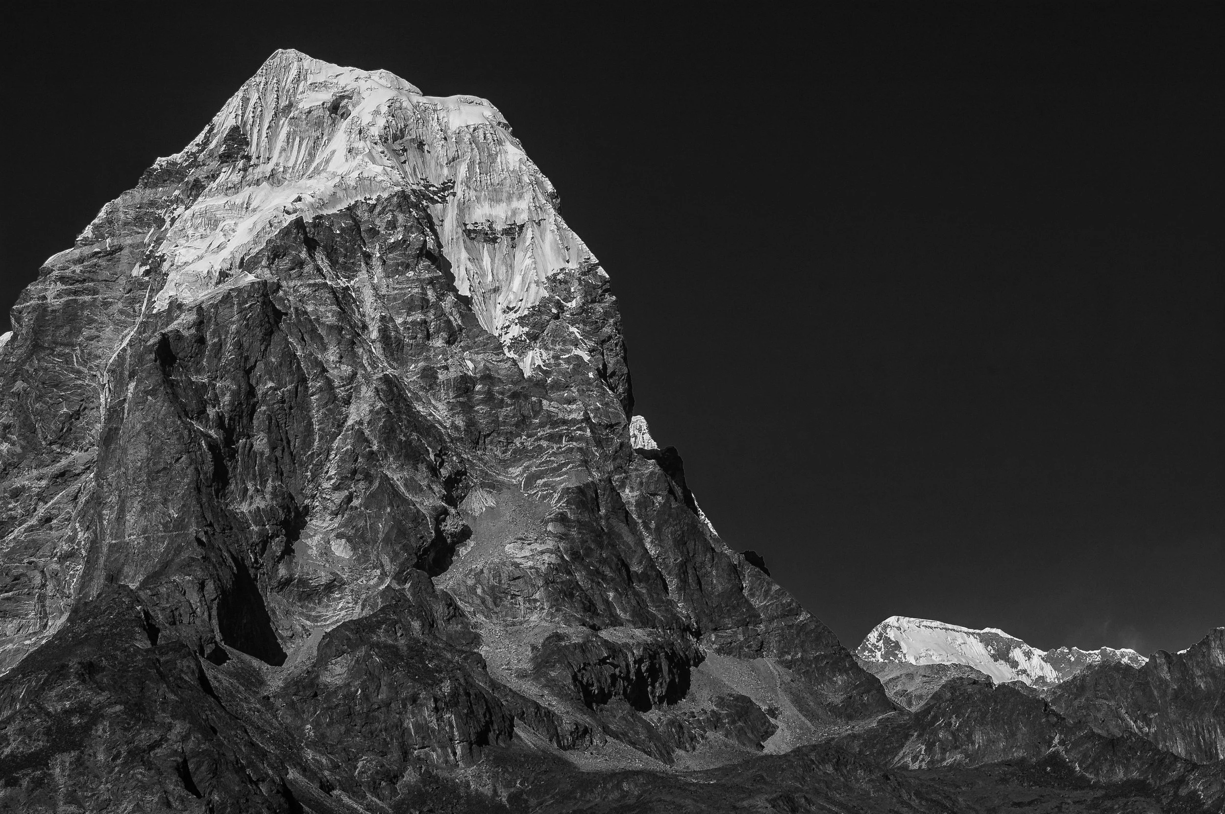
Until We Act, the Mountains Will Keep Changing
A climate & culture archive capturing Nepal’s aerial truth in black and white fine art.
UNTIL WE ACT
FROM A PHOTOGRAPH TO A VISUAL ARCHIVE.
Until We Act expands that thinking further through long-term visual documentation across the Hindu Kush Himalayas and, ultimately, other vulnerable landscapes around the world.
Aerial photography. Ground expeditions. Film. Environmental documentation. Human stories. Research. Education. Publications. Exhibitions.
The photograph can be the beginning of a much larger record.
WHERE COULD YOUR AERIAL COMMISSION GO?
A magazine. A book. A campaign. A museum. A gallery. A scientific publication. A conservation report. A tourism campaign. An architectural portfolio. A documentary. A research archive. A national or international news story. A corporate communication project.
Or simply one extraordinary photograph that nobody else has.
The application determines the opportunity.
WHAT WE CAN COMMISSION
ONE IMAGE OR A COMPLETE AERIAL VISUAL PROJECT.
Editorial aerial photography. Commercial aerial photography. Architecture. Real estate and hospitality. Tourism and destinations. Environment and conservation. Climate documentation. Infrastructure. Heritage. Research. Documentary. Fine art. Books and publications. Campaigns. Long term visual archives.
If the subject matters, there may be a way to photograph it from above.
AERIAL PHOTOGRAPHY FOR PEOPLE WHO NEED THE RIGHT IMAGE
This is not a recreational drone service.
It is not a cheap aerial add-on.
And it is not about putting a drone into the sky because aerial photographs look impressive.
It is for organisations, brands, publishers, photographers, researchers, architects, filmmakers, agencies and individuals who have a serious visual objective.
If the photograph matters, the operation matters.
WHAT IF YOU WANT TO LEARN IT YOURSELF?
PROFESSIONAL AERIAL & DRONE PHOTOGRAPHY LEARNING
Already a photographer? Want to take your work into the air?
We can develop a tailored learning experience around aerial composition, flight planning, camera decisions, permissions, safety and the practical realities of making serious photographs from a drone.
ENQUIRE ABOUT AERIAL PHOTOGRAPHY LEARNING →
THEN THERE IS THE HELICOPTER WITHOUT A DOOR.
LEARN HELICOPTER AERIAL PHOTOGRAPHY
For those who want to go further, Open Door Himalayan Helicopter Photography is Gautam Dhimal's intensive private photographic experience in Nepal.
Six days. One or two participants. Open door helicopter photography, ground work, mentoring and the freedom to make your own photographs across the Himalayas.
Not sightseeing. Photography from the air.
TELL US WHAT YOU NEED TO SEE
You do not need to know which aircraft. You do not need to know which lens. You do not need to know how the permissions work.
Send us the location, subject, reference, idea or objective.
We will assess the photographic possibilities and determine what the assignment requires.
Sometimes the answer is a drone.
Sometimes it is something else entirely.
AERIAL & DRONE PHOTOGRAPHY NEPAL
Professional Aerial Imaging For Serious Commissions.
Location Nepal · Gautam Dhimal · Nepal · Himalayas